

Sewers and wastewater · Existing assets without drawings
Sewer documentation for older existing property in Vienna, Lower Austria and Burgenland
In older existing property the most frequent answer to the question about the sewer drawing is a shrug. There is none, or there is one that was correct three conversions ago. Anyone who carries out rehabilitation on that basis is planning blind: the tender names metres that nobody has measured, and the excavator finds a pipe run that no drawing knows about. This service comes before that. CFT surveys the existing network with a steerable camera – into the lateral connections as well – marks the route at the surface, draws it into the orthophoto and the as-built plan and hands over the documentation before money is spent on rehabilitation. We work in Vienna, Lower Austria and Burgenland: a short journey and prompt appointments. Scope and appointment are settled on +43 (0) 2252 53169.

What we do on site
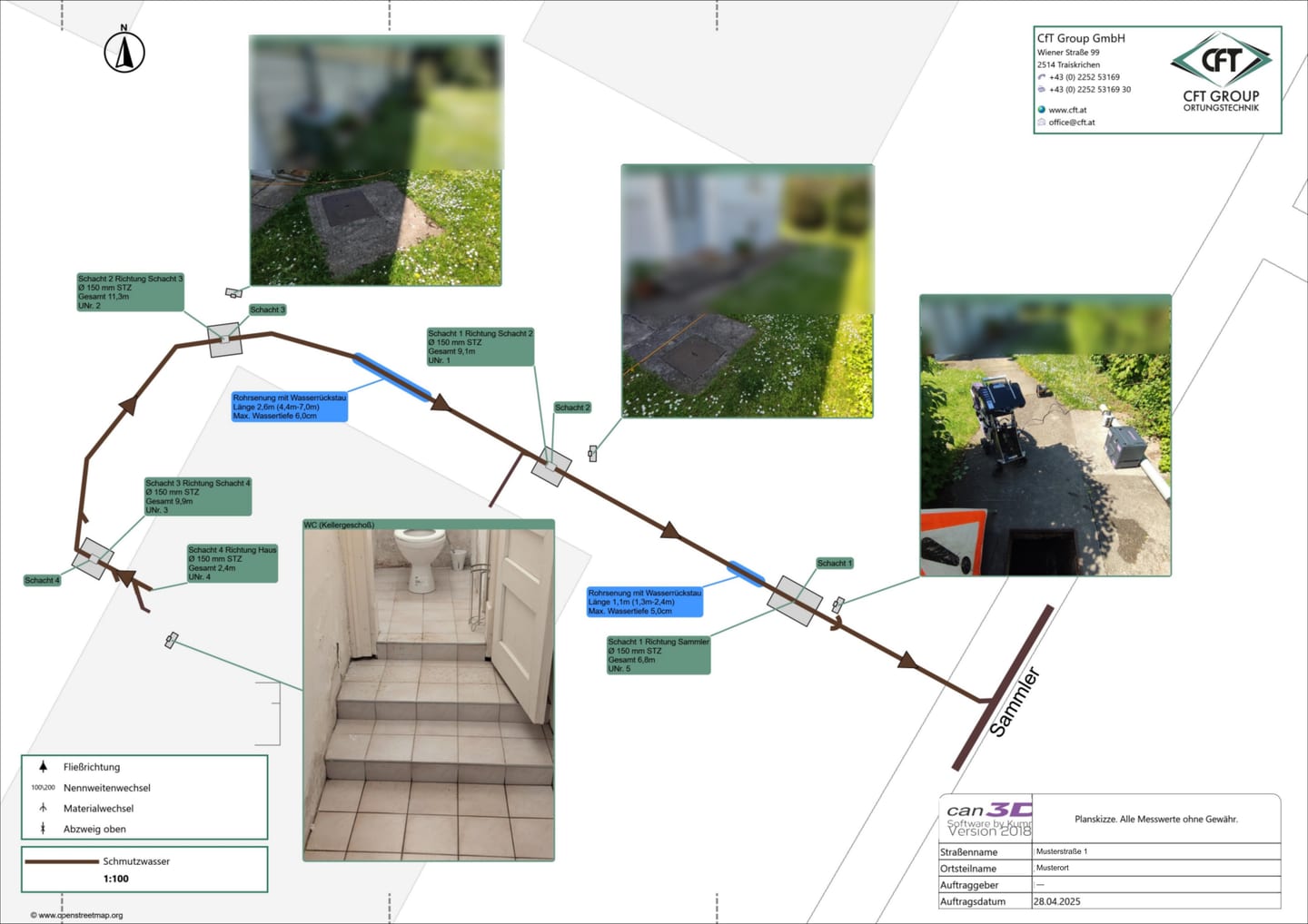
We work our way through the network from manhole to manhole and survey the runs with camera equipment capable of several turns, which also enters the branches. The digital representation of the route is produced in the process; at the surface it is marked and then drawn in – outdoors into the orthophoto, indoors into the record plan. You receive a sketch of the route, documentation of the mains and an inspection report for each pipe surveyed.
Key facts at a glance
| Methods | Multi-turn steerable camera equipment, digital reconstruction of the pipe network route, surface marking, drawing into the orthophoto and the as-built plan, survey with GPS or total station on request |
|---|---|
| Application range | Existing properties without drawings or with unusable drawings: residential buildings, yards, gardens and driveways |
| Duration | Typically 2 to 4 hours, depending on the size of the network and access to the manholes. |
| Result format | Route sketch, pipe documentation, digital representation of the pipe network route, surface marking, route drawn into the orthophoto and the as-built plan, photographic report, one inspection report for each pipe surveyed |
| Service area | Vienna, Lower Austria and Burgenland |
For you as a private customer
You have inherited a house, bought one or lived in one for thirty years, and nobody knows where the underground drain runs. That becomes a problem precisely when rehabilitation or an extension is planned. We record what is actually there: which pipe run leads where, where manholes sit, at what depth the route runs. You get the route marked and as a sketch – a basis on which you can compare quotations instead of having to believe them.
How the job runs
1. Reviewing what exists. You gather together what there is – old drawings, planning submission documents, utility records enquiries – and we tell you what of it is any use.
2. Finding the access points. In older property, manhole covers and rodding eyes are often surfaced over with tarmac or overgrown. No access, no recording, which is why this comes first.
3. Pre-cleaning. In pipes that nobody has checked for decades, deposits have settled. We therefore recommend high-pressure pre-cleaning: otherwise a blocked lateral connection stays undetected and is missing from the documentation at the end.
4. Survey run and marking. The pipe runs are surveyed and the lateral connections are included. This produces the digital representation of the route; at the same time the route is marked at the surface, and lateral connections and manholes are allocated.
5. Drawing in. Outside, the marked pipe run is taken off against the orthophoto and drawn in there; in interiors it goes into the as-built plan. Where it has to be positionally correct, we survey the points in with GPS or a total station on request.
6. Documenting and handover. You receive the route sketch, the pipe documentation, the drawings, images and, for each pipe surveyed, the inspection report. Planning and construction are carried out by your designer or pipe rehabilitation contractor.
Equipment and methods
Multi-turn steerable camera equipment
In older existing property it is not even settled how many lateral connections there are at all – so not only the main pipe run is surveyed but every lateral the head finds: it turns in and carries on, over several branches in succession as well. What a rigid head passes as a dark hole becomes part of the recording in this way, and with it part of the drawing that did not exist until now. Work is carried out from DN 100 to DN 200. Where the head cannot get through – a blockage, ponded water, a collapsed section – the run ends; the point reached is marked at the surface and noted as an end point.
Digital reconstruction of the pipe network route
The run records the distance travelled, direction and gradient; from this the route of the network is produced as a digital representation. For a property without a drawing this is the first connected picture of any kind: which pipe run hangs on which, where the fall runs, where a lateral ends blind. It remains a route model and not a survey drawing – coordinates arise only where surveying in is added.
Surface marking
The recorded route is marked on tarmac, paving or grass, with the centreline, the lateral connections and depth readings – the result that counts on site. Its limit is durability: paint does not survive rain and traffic for long. That is why the route is additionally transferred into a document.
Drawing into the orthophoto and the as-built plan
So that the route outlasts the paint, it is transferred into a document. In the open this is done by taking it off against the orthophoto: the marked points are taken off against the aerial image and the pipe run is drawn into it – building edges, paths and kerbs provide the reference. In interiors the as-built plan takes that place, and there the route is entered into the floor plan. Both are a transfer by drawing and not a survey: they show reliably where the pipe lies and where it leads, without asserting coordinates.
Survey with GPS or total station, on request
Where it is needed positionally correct – because there is to be building over the route, or because the route is to go into an asset record – we additionally survey the marked points in with GPS or a total station. That is a separate item and is carried out only to order; without it, the route stays as drawn in.

What you receive
Four documents that hold the same network from different directions: the route sketch with manholes and lateral connections, the pipe documentation that goes with it, the digital representation of the pipe network route and the photographic report. Outside, the pipe run is additionally drawn into the orthophoto, inside into the as-built plan – the marking on tarmac, paving or grass is what is worked with on site, the drawing is what remains once the paint has gone.
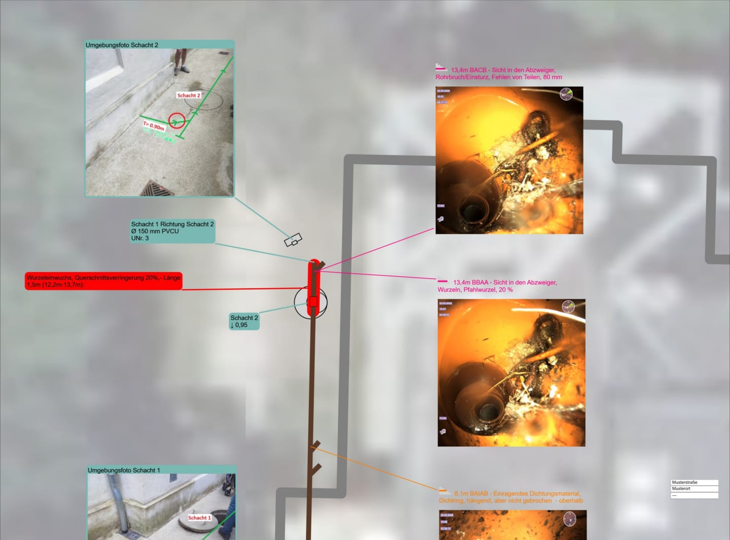
For every pipe surveyed there is a separate inspection report. Pipe run by pipe run it holds what the camera saw – what is a notable feature and what is defective, each with the distance in metres and its position in the network. Defective points are additionally set out above ground, as a marking on the property.
With every entry it is stated what has been measured and what is assumed. A designer or pipe rehabilitation contractor then calculates on evidenced metres instead of estimated ones.
We show what we find.
Two real results from older stock – the plan sketch of a buried drain and the documented main drain of a private house.
Costs and effort
There is no flat rate, because the size of the network, accessibility and the depth of recording determine the effort; we agree the cost range beforehand. Our re-survey rule applies to the location work: if our measurement was wrong, we re-survey free of charge. If it was correct and the search was simply not careful enough or the excavation not deep enough, the call-out is charged. The trace and access cover of buildings insurance relates to leak detection after an escape of water and does not apply here.
Frequently asked questions
We have no drawing at all. Is that enough to start from?
Yes, that is the normal case. We begin at the access points and work our way through the network from manhole to manhole. An old drawing helps, but it is not a precondition.
Does this also show us whether the sewer is damaged?
For every pipe that is surveyed, yes: the report names what is a notable feature and what is defective, and where in the pipe run it sits. What cannot be surveyed appears in the route but not in the condition – we say so rather than gloss over it.
What happens to pipe runs that cannot be surveyed?
The run ends where it ends. The point reached is marked and carried into the sketch and the drawing as an end point; the section beyond it stays identified as an open point. A guessed line on a drawing would be the opposite of helpful in older property.
Do you then carry out the sewer rehabilitation as well?
No. CFT surveys, marks, draws in and documents; planning and construction are carried out by your designer or pipe rehabilitation contractor. That is precisely why we hand over the recording as completely as it is – including the sections that have remained impassable.
Contact and opening hours
CFT Group GmbH, Wiener Straße 99, A-2514 Traiskirchen, +43 (0) 2252 53169, for properties in Vienna, Lower Austria and Burgenland. Monday to Thursday 8:00–16:30, Friday 8:00–12:00. Outside office hours in writing to office@cft.at, and we will come back to you on the next working day.
Related services
3D survey and laterals
The same camera equipment, but cut to the underground drain beneath the house and its lateral connections instead of the whole property.
Drain and pipe cleaning
The pre-cleaning without which blocked lateral connections are missing from the recording.
Pipe and utility detection
When the question is not the sewer but water, gas or electricity services on the same property.
Locating buried manholes
The step before, when manholes in older property have been surfaced over with tarmac or buried.
Describe what you are observing.
Just describe what you see – add a photo, and we can often settle on the right method before we even call back.
What happens next
- We read your message and match the case to a method.
- We come back to you – usually with a question that shortens the appointment.
- We confirm the appointment and what it costs before anyone sets off.
Rather talk?
+43 (0) 2252 53169
Mon–Thu 8:00–16:30 · Fri 8:00–12:00
Describe your case.
Fastest by telephone – then we settle straight away which method fits and what you should prepare.
Outside office hours, write to office@cft.at.