

Locating and surveying
Site and route utility clearance surveys in Austria and southern Germany
A digger bucket striking an unknown service costs time and money – with electricity and gas mains it puts people at risk. The site and route utility clearance survey establishes beforehand what lies underground: unknown services are traced, and the position of known services is confirmed. You receive the area marked out and as a data set – before the first excavator arrives.

What we do on site
We bound the field to be investigated together with you and work through conspicuous areas more closely until the finding is unambiguous. The surface has to be walkable and driveable; the cleaner it is, the tighter the grid we run. Whatever we cannot assign unambiguously appears as such in the report.
Key facts at a glance
| Methods | Ground penetrating radar (GPR), grid scan and focused area investigation, locating foundations and vaults, electromagnetic cable locating, pipe sonde location, survey with GPS and total station |
|---|---|
| Application range | Construction sites, routes, industrial sites and building floor areas, roads and paved areas, historic ground |
| Duration | One day to several days, depending on the scope of the job |
| Result format | Marking on site, documentation as .shp, .gpkg, .dwg, .dxf and .pdf |
| Service area | The whole of Austria from the head office in Traiskirchen; southern Germany (Bavaria and Baden-Württemberg) via CFT Group Deutschland GmbH, Lange Zeile 27, D-85435 Erding |
For you as a business
For the construction industry, industrial operators, local authorities and network operators, the clearance survey is the basis for the permit to dig. It supplements the network operators’ utility records enquiry with what appears in no record: abandoned routes, cables laid as a temporary measure, services from the years before digital documentation. We supply the results in the formats that design teams and site management work with.
We carry out this service beyond our immediate region: because ground penetrating radar, grid scanning and the subsequent evaluation justify the journey, we come out to sites throughout Austria and in southern Germany – in Austria from the head office in Traiskirchen, in Bavaria and Baden-Württemberg from the Erding site.
All the usual utilities on a construction site are covered:
- Ducts
- Sewers, drinking water mains and fire mains
- Heating and district heating pipes
- Gas mains
- Data cables
- Low-, medium- and high-voltage
How the job runs
1. Setting out the area. You supply the site plan, the construction drawings and the existing utility records enquiries. Together we define the area to be investigated. Appointments for sites in Austria are arranged on +43 (0) 2252 53169, for sites in southern Germany on +49 (0) 173 6842932, Monday to Thursday 8:00–16:30, Friday 8:00–12:00.
2. Preparing the area. The area has to be accessible on foot and by vehicle: vegetation cut back, rubble and stored material removed, vehicles moved away. The cleaner the surface, the tighter the grid that can be run.
3. Surveying. We lay a grid over the area and run it with ground penetrating radar, with electromagnetic cable locating running alongside. We investigate conspicuous areas more closely, until the finding is unambiguous.
4. Marking and handover. The results are marked on site, surveyed in and handed over as a data set. Anything we cannot assign unambiguously is stated as such in the report.
Equipment and methods
Ground penetrating radar (GPR)
An antenna sends short electromagnetic pulses into the ground. At every interface with different electrical properties – a pipe wall, a void, the edge of a foundation, a change of stratum – part of the pulse is reflected and recorded as a travel time. This lets ground penetrating radar find plastic pipes without tracer wire, concrete elements and voids as well. Its limit is the ground itself: in conductive, cohesive or water-saturated material the penetration depth falls; high antenna frequencies resolve finely but reach less deep.
On historic ground the same method becomes a preliminary investigation: old wall lines and forgotten services are mapped without any digging. The survey does not, however, date anything and does not replace an excavation.
Grid scan and focused area investigation
A grid is laid over the area and scanned across its full extent; the individual lines are combined so that a map of the hidden installations emerges. In a focused area investigation, a critical part of the area is worked through with close depth resolution. The grid spacing decides what is found. The lines are run in two mutually perpendicular directions, because an object lying parallel to the scan line produces no hyperbolic reflection in the radar image.
Locating foundations and vaults
The same equipment shows foundations, vaults, backfilled cellars and other remains of structures before a conversion or a demolition is planned – together with foundation dimensions and the location of cisterns, greywater, oil and fuel tanks. In industrial buildings we check thermally activated building components so that core drilling does not hit a heating loop.
Cable locating and pipe sonde location
Metallic services are additionally covered electromagnetically, pipes by means of an inserted sonde. How this works in detail is described on the page on pipe and utility detection.
Survey with GPS and total station
A GNSS receiver on the survey pole determines the position of every located point from satellite signals, corrected via a reference correction service. Only this turns the colour marking into a data set for GIS and CAD. Between the walls of a building, under dense tree canopies or beneath overhead structures the accuracy breaks down – there the total station takes the place of satellite reception and measures direction and distance from a known station. Either way, everything we locate is surveyed in; that is not an additional order but part of the clearance survey.
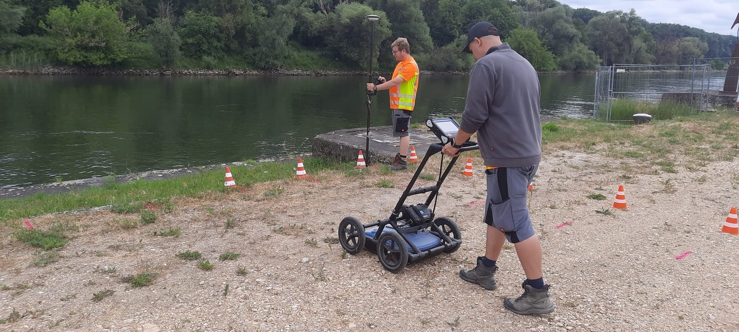
How we work in the field.
A real job: the staked-out field on the riverbank, driven pass by pass with the ground penetrating radar – and georeferenced via GPS.

What you receive
On site: marked routes, flagged areas of suspected services and points that should be opened by hand before excavation. On the data carrier: the surveyed-in detection data as .shp and .gpkg for the GIS, as .dwg and .dxf for CAD and design work, and a .pdf as a readable plan for site management and site meetings. Every located point is surveyed in – there is no reduced version here in which points are only marked and not recorded.
Costs and effort
There is no flat rate. The effort involved and the cost range depend on the area, the grid spacing, the ground and the deliverable format you want, and are agreed by telephone before the job. Trace and access cover under buildings insurance applies to leak detection after an escape of water, not to a planned clearance survey before construction begins.
Re-survey. It is part of the scope of work. If excavation shows that a position we marked is not correct, we re-survey free of charge. If, on the other hand, the marking was correct and the digging was done beside the marked route or not deep enough, we charge for the call-out, because in that case there is no measurement error on CFT’s part.
Frequently asked questions
Does the clearance survey replace the network operators’ utility records enquiry?
No. The network operators’ records enquiry still has to be obtained. The clearance survey checks whether the position on the ground is actually correct, and additionally finds what is listed in no records enquiry.
What applies if a service is not where it was marked?
Then we re-survey; that is part of the scope of work. If our measurement was wrong, the re-survey costs you nothing. If the marking was correct and the excavation was simply not made precisely enough at the marked point or not deep enough, we charge for the call-out, because in that case there is no measurement error on CFT’s part. The same rule applies to cable fault location, cable locating and pipe locating.
How deep does ground penetrating radar reach?
That depends on the ground and on the antenna, not on the equipment manufacturer. Dry gravel allows a deep view, damp clay hardly any.
What do I have to prepare so that the area can be surveyed?
A surface that can be walked on, without tall vegetation, heaps of rubble and parked vehicles. Heavily overgrown or deeply rutted areas noticeably reduce the data quality.
Do you also find old tanks and cisterns?
Yes. Cisterns, greywater, oil and fuel tanks are among the structures we locate. We do not carry out removal and disposal; we mark the position and hand it over.
Describe the findings.
The more precisely you describe the findings, the more directly we can go to work. Plans, readings and photos help us settle the method in advance.
What happens next
- We read your message and match the case to a method.
- We come back to you – usually with a question that shortens the appointment.
- We confirm the appointment and what it costs before anyone sets off.
Rather talk?
+43 (0) 2252 53169
Mon–Thu 8:00–16:30 · Fri 8:00–12:00
Describe your case.
Fastest by telephone – then we settle straight away which method fits and what you should prepare.
Outside office hours, write to office@cft.at.